SOUTH24 CENTER FOR NEWS & STUDIES
SOUTH24 CENTER FOR NEWS & STUDIES


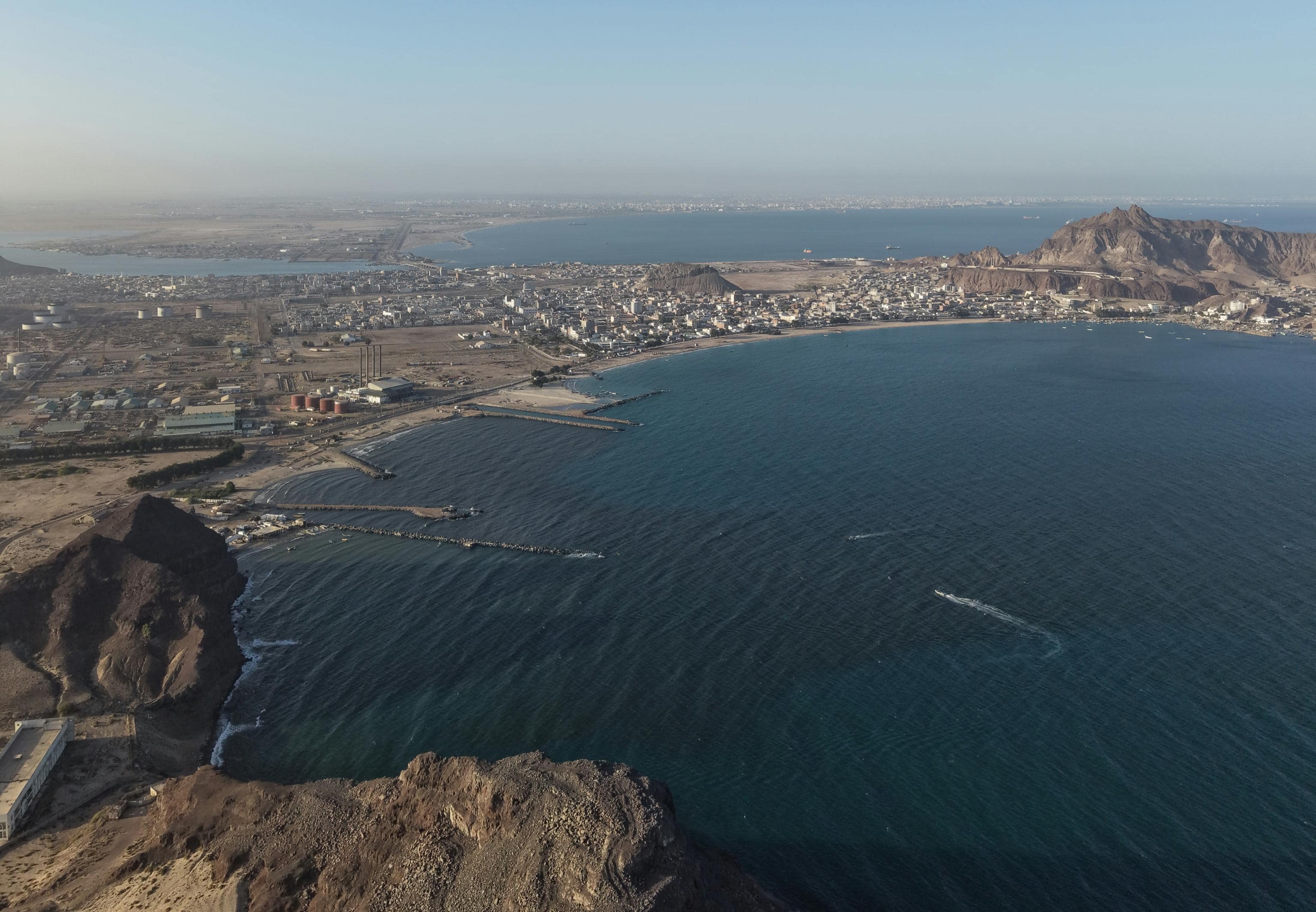
An aerial view of the coast of Al-Buraiqa District, west of Aden, April 17, 2026. (Photo: South24 Center)
Last updated on: 05-09-2026 at 9 PM Aden Time
Aden (South24 Center)
A new study by South24 Center for News and Studies has identified wide variations in the nature and severity of climate risks facing coastal cities and areas in South Yemen. It warns that cyclones, flash floods, coastal inundation, heat stress, and desertification could have increasingly severe impacts on populations, public services, infrastructure, water resources, and livelihoods amid fragile local capacities and limited preparedness and adaptation.
The study, titled “Climate Change Impacts on Coastal Cities in South Yemen (2015–2050),” was prepared by researchers Zaher bin Sheikh Abu Bakr and Hisham Al-Kaf. It concludes that Aden and Hadramout rank among the areas with the highest priority for climate intervention, while Abyan and Al-Mahra face high levels of risk. Shabwa and Lahj require targeted interventions, particularly in areas affected by flash floods and around wadi outlets, as well as in agricultural zones and around roads and economic and service facilities.
Supported by Urgent Action Fund, the study emphasizes that climate risk is not determined solely by the severity of a natural hazard or the size of the area exposed to it. Rather, it is shaped by the interaction between hazard, exposure, and vulnerability, including population density, the location of critical infrastructure, the condition of infrastructure and services, land use, and institutional and community capacity to respond and adapt.
Six Governorates and Climate Scenarios Through 2050
The study covers the governorates of Aden, Lahj, Abyan, Shabwa, Hadramout, and Al-Mahra. Its historical and current assessment covers the period from 2015 to 2025, while its projections extend to 2050.
It examines cyclones and tropical storms, flash floods and flooding, sea-level rise and coastal inundation, extreme heat, heat stress and urban heat islands, as well as desertification, land degradation, and saltwater intrusion.
The researchers adopted an approach combining descriptive, spatial, and forward-looking analysis, using geographic information systems, remote sensing, digital elevation models, building and infrastructure data, sea-level rise projections, and land surface temperature data.
The fieldwork also included a closed-ended survey involving 62 specialists, academics, and others with an interest in climate issues across the six governorates, as well as two focus group discussions in Aden and Hadramout. The survey findings were used to interpret the spatial data and understand local experiences and perceptions, not to represent the wider population.
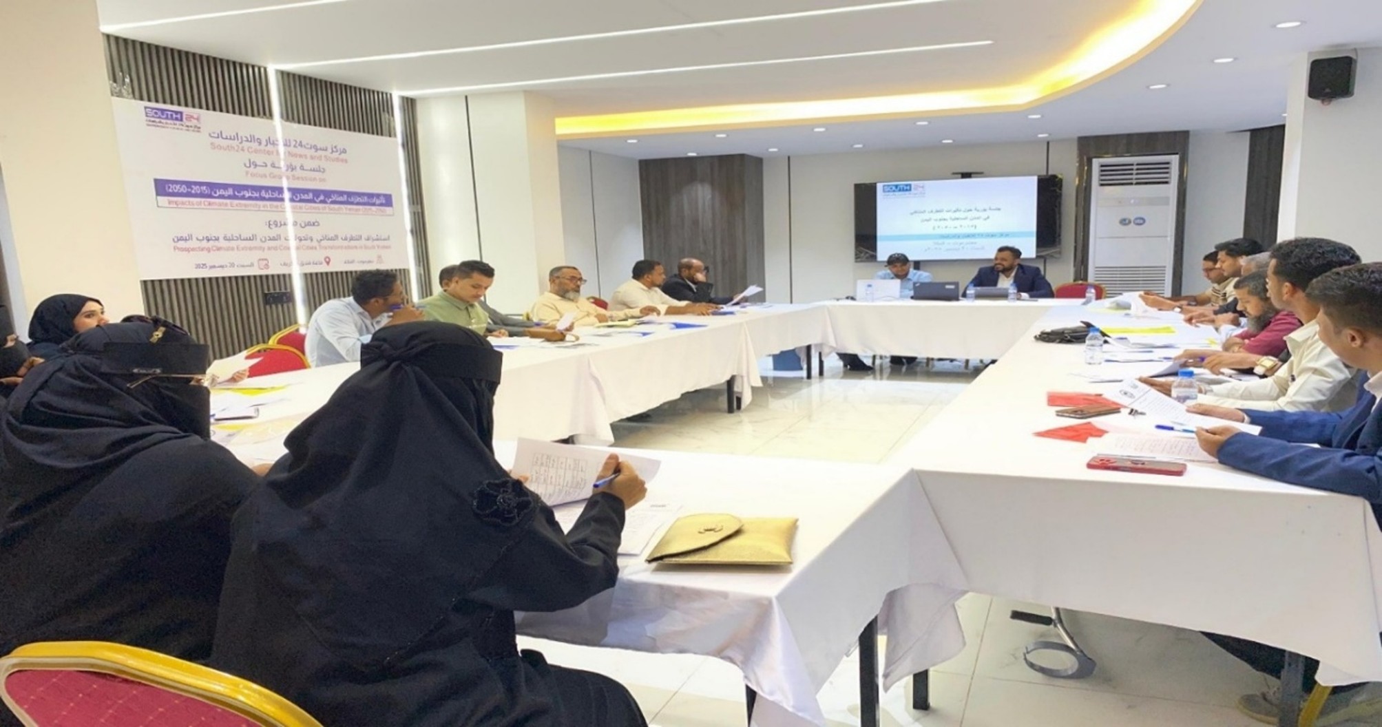
Photo 3-1: Focus group discussion organized by the study team in Mukalla, Hadramout Governorate, to discuss climate risks and adaptation priorities in South Yemen’s coastal cities.
Climate Risks Vary Across South Yemen’s Governorates
A review of the 2015–2025 period found that South Yemen’s coastal governorates were repeatedly exposed to cyclones, storms, flash floods, and flooding, alongside worsening desertification, land degradation, and saltwater intrusion. These hazards caused damage to homes, roads, bridges, electricity and telecommunications networks, water sources, health facilities, agricultural land, and livelihoods.
However, the study emphasizes that the risk profile is not the same across all governorates.
Hadramout and Al-Mahra are more exposed to the paths of storms and tropical cyclones originating in the Arabian Sea, while flash-flood and wadi-related risks are particularly prominent in Lahj, Abyan, Shabwa, and Hadramout.
In Aden, urban flooding, localized coastal inundation, and heat stress are of particular concern because of the concentration of population, services, and critical infrastructure, the presence of low-lying areas close to the coast, and the limited capacity of drainage networks to handle heavy rainfall.
The impacts of desertification, land degradation, and saltwater intrusion also extend to groundwater, agriculture, food security, and the stability of rural communities. The survey found that 79% of respondents perceived a notable expansion of desertification and land degradation across the targeted governorates during 2015–2025. This finding reflects the perceptions and experiences of participants and does not constitute a direct measurement of the area of degraded land.
According to the study, flash floods and flooding do not become crises solely because of the amount of rainfall. Their impact is compounded by construction in flood channels, inadequate drainage, fragile roads, bridges, and other infrastructure, and declining local preparedness and response capacity.
What Does the Sea-Level Rise Scenario Reveal?
The study devoted part of its analysis to projecting potential exposure to coastal inundation through 2050. It used the high-emissions SSP5-8.5 scenario, along with an operational reference value of 0.23 meters of sea-level rise.
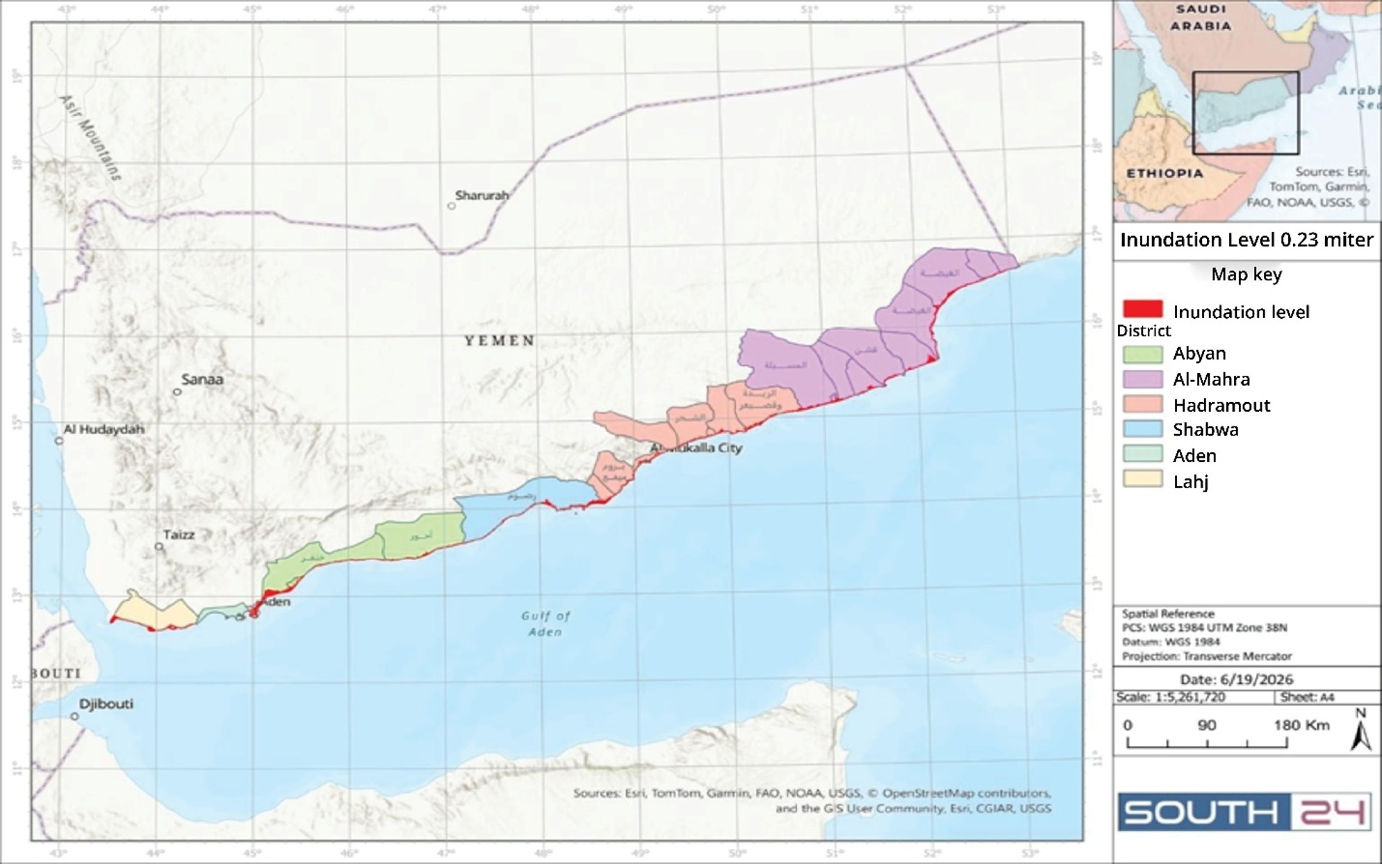
Map 3-1: Spatial extent of the 0.23-meter sea-level rise scenario across the target governorates through 2050.
The study stressed that this figure does not represent a definitive forecast of what will happen along South Yemen’s coast. Rather, it serves as an input for identifying low-lying land and assets that could potentially fall within the exposure zone under this scenario. The model also does not provide detailed simulations of waves, tides, storm surges, land subsidence, drainage networks, or coastal barriers.
The modeling results showed significant variations in the estimated areas potentially exposed to coastal inundation.
Abyan recorded the largest estimated area, at approximately 43.47 square kilometers, most of it concentrated in Khanfar District. It was followed by Al-Mahra, with approximately 42 square kilometers, particularly in Al-Ghayda, Al-Masila, Haswayn, and Sayhut.
In Lahj, the estimated exposed area was approximately 20.21 square kilometers, concentrated mainly in Al-Madaraba and Ras Al-Ara. Shabwa recorded 17.24 square kilometers, covering areas including Radum, Bir Ali, Balhaf, and wadi outlets.
Hadramout recorded approximately 15.90 square kilometers, distributed across Brom, Al-Raydah, Qusay'ar, Al-Dis, and Mukalla. Aden recorded the smallest estimated area, at approximately 1.50 square kilometers, concentrated in Khor Maksar, Al-Mualla, and Crater.
However, the study cautioned against interpreting these figures as a direct ranking of risk levels. A smaller exposed area does not necessarily mean lower potential losses.
Aden is the clearest example. Despite having a relatively small area of potential exposure compared with the other governorates, the concentration of population, services, and strategic facilities within a limited urban area increases its vulnerability and makes it a high priority for intervention.
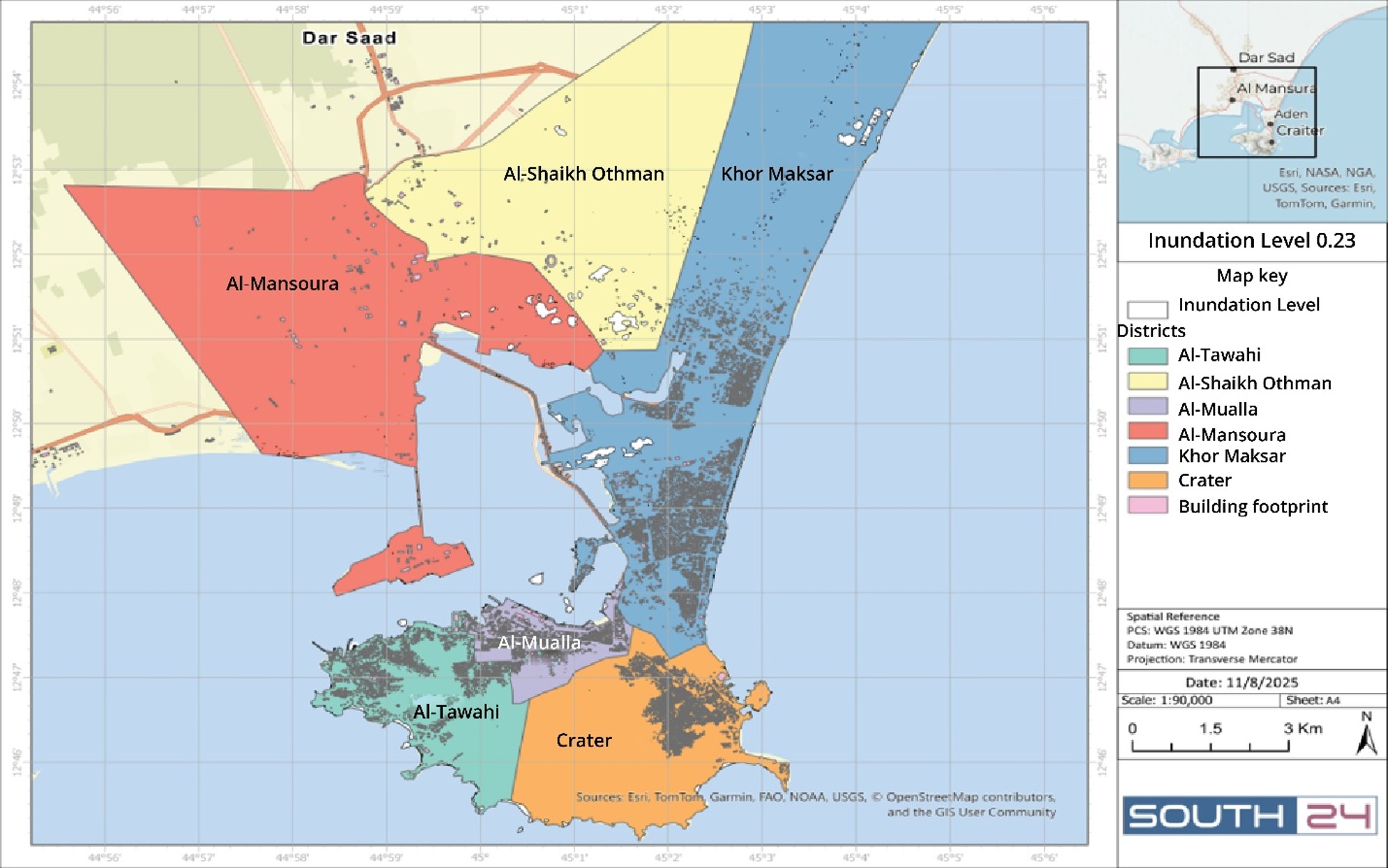
Map Appendix 2-5: Spatial distribution of areas exposed to coastal inundation across the districts of Aden City under the 0.23-meter sea-level rise scenario through 2050, based on spatial modeling using a digital elevation model (DEM).
Heat Stress: A Slow-Moving Risk Rising Through 2050
The study identifies heat stress and urban heat islands as growing climate risks in South Yemen’s coastal cities. These are slow-onset hazards whose impacts extend to public health, workers’ ability to perform and remain productive, electricity and water consumption, and overall quality of life. Vulnerability increases as coastal heat and humidity interact with urban expansion, limited tree cover and shade, and the widespread use of concrete and asphalt surfaces that absorb heat and gradually release it.
According to the reference indicators used in the study, Yemen’s average annual temperature during 1991–2020 was approximately 25.54°C, while the average rate of temperature increase between 1971 and 2020 was approximately 0.42°C per decade. The projections used in the study indicate a potential increase of up to 1.69°C by 2050, while some high-emissions pathways project increases ranging from 1.7°C to 2.4°C. The indicators compiled by the study also suggest that more than five million people in Yemen could potentially be exposed to wet-bulb temperatures exceeding 35°C during a rare event, with exposure concentrated in Aden, Hadramout, and Hodeidah. They also point to a potential tenfold increase in heat-related illnesses between 2020 and 2050.
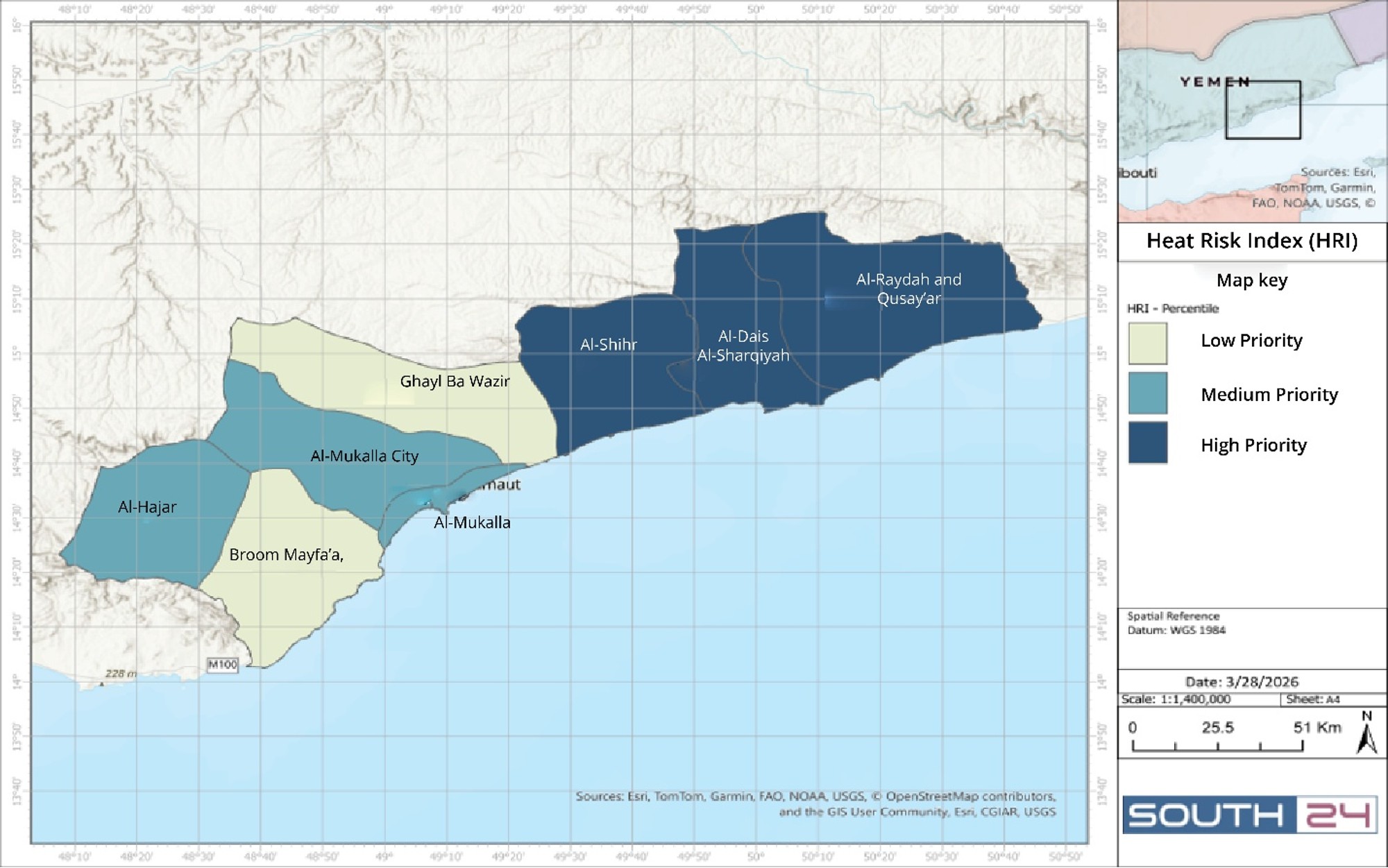
Map Appendix 2-3: Spatial distribution of average heat-risk index categories across the coastal districts of Hadramout Governorate.
To assess heat risk spatially, the study used Landsat imagery to derive land surface temperatures and combined these data with vegetation cover, urban density, and population density to develop a heat risk index and identify high-priority hotspots. It cautioned that land surface temperature does not represent air temperature or directly measure the heat stress experienced by people. Rather, it is used to identify temperature variations within cities and pinpoint areas where hot surfaces coincide with limited vegetation and high population concentrations.
The findings show significant variations across the governorates. In Aden, the study classified heat risk as high, linking it to urban density, humidity, limited tree cover and shade, and pressure on electricity and water supplies. In Hadramout, particularly Mukalla, the risk is associated with coastal heat stress, urban heat hotspots, urban expansion, and extensive hard surfaces. In Lahj, Abyan, Shabwa, and Al-Mahra, vulnerability ranges from moderate to high and is more closely linked to outdoor work, agriculture, fishing, water scarcity, and limited shade and services.
In Shabwa, the spatial analysis identified high-priority heat-risk areas in Bayhan, Usaylan, Upper and Lower Markha, Nisab, Ataq, and Mayfa’a. This indicates that the risk is not confined to the coastal strip but also extends to inland districts where high temperatures coincide with population concentrations and limited vegetation cover.
A Risk That Outlasts the Storm
One of the study’s key findings is that the impacts of climate events do not end when a storm passes or floodwaters recede. They can persist through disruptions to roads, services, and supply routes, damage to agricultural land and wadi outlets, and rising recovery costs.
Multiple hazards can also compound one another’s impacts, such as when flooding occurs alongside coastal inundation or extreme heat coincides with power outages and water shortages.
The study finds that the readiness of services, infrastructure, and local authorities is a critical factor in determining the scale of losses. Improving drainage networks, protecting roads and facilities, strengthening early warning systems, and regulating land use can reduce risk even in highly exposed areas.
It also concludes that no single intervention model can be applied across all governorates because needs vary among densely populated cities, agricultural areas, wadi channels, coastal zones, and economic sites. The study further notes that the lack of detailed data continues to limit the ability to produce accurate estimates of losses and costs at the district, neighborhood, and facility levels.
Where Should Intervention Begin?
The study places Aden and Hadramout in the very high-priority category but identifies different risk drivers and intervention needs in each governorate.
In Aden, urgent measures include clearing stormwater drainage channels, protecting critical facilities, preparing evacuation plans, and activating warning systems for floods and heatwaves. These should be followed by upgrades to drainage networks, expanded tree cover and shading, improved efficiency of critical facilities, and regulation of urban expansion away from low-lying areas.
In Hadramout—particularly Mukalla, coastal areas, and wadi outlets—priorities include early warning and evacuation systems, clearing flood channels, and protecting roads and facilities. Longer-term measures include developing coastal protection solutions and integrating coastal management with wadi and flood management.
The study places Al-Mahra and Abyan in the high-priority category. In Al-Mahra, the focus should be on preparedness for storms and floods and securing roads and coastal communities. In Abyan, priorities include protecting communities and agricultural areas and managing flooding, coastal inundation, and salinity.
Shabwa and Lahj fall within the moderate-to-high priority range. In Shabwa, the study highlights the need to protect roads, transport corridors, and coastal economic sites. In Lahj, priorities center on flood channels, agricultural areas, and low-lying coastal zones.
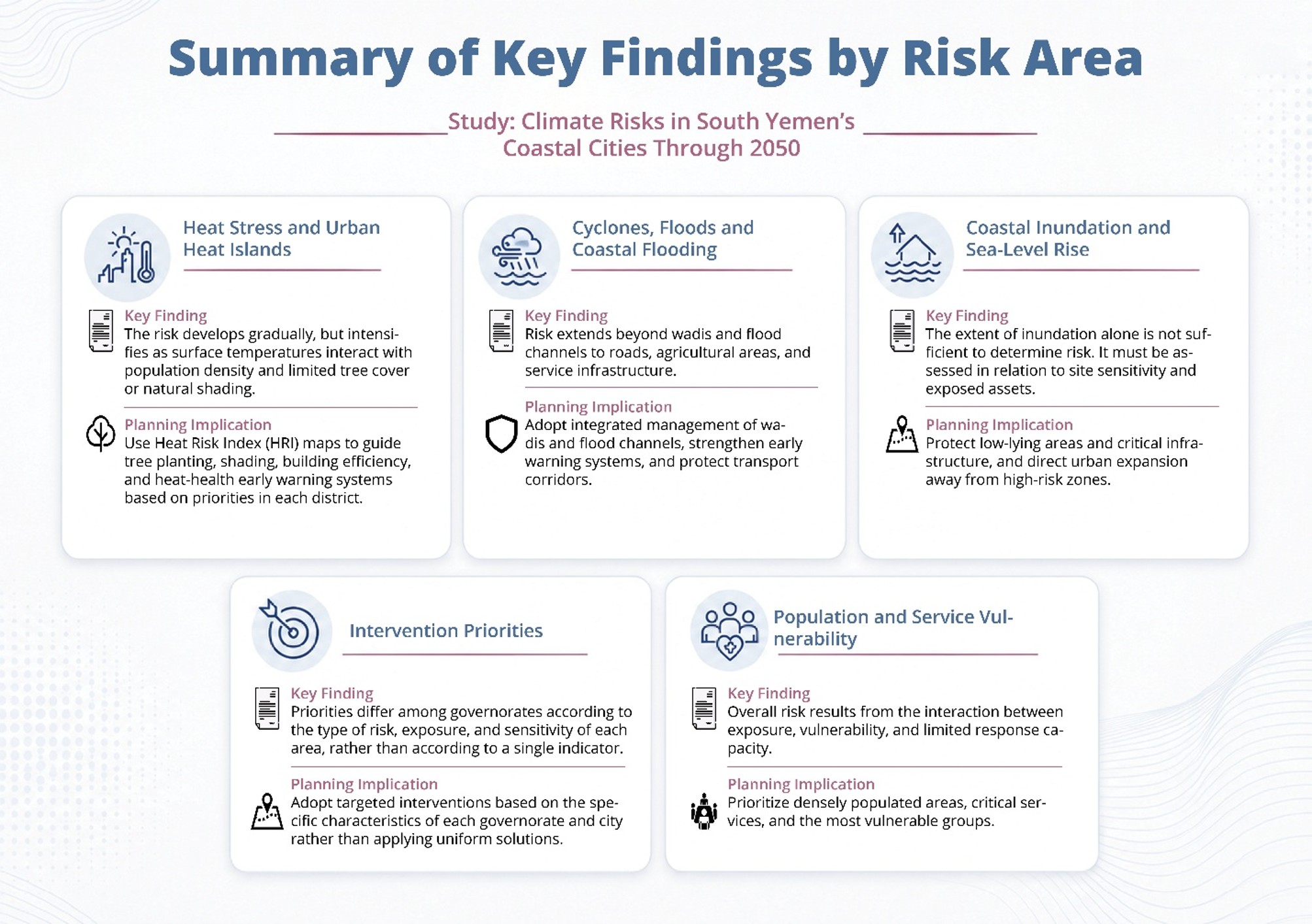
Figure 3-2: Summary of the key findings and planning implications for addressing climate risks in South Yemen’s coastal cities through 2050.
Strategic Recommendations
The study puts forward several strategic recommendations aimed at reducing climate risks and strengthening the adaptive capacity of coastal cities and communities.
It calls for adopting coastal protection solutions that combine engineering interventions with nature-based approaches, prioritizing low-lying areas, critical facilities, and wadi outlets.
It also recommends clearing and reopening flood channels, improving culverts and bridges, preventing construction along drainage routes, establishing a multi-hazard early warning system covering cyclones, flash floods, coastal flooding, and heatwaves, and linking it to local evacuation and response plans and training.
In urban areas, the study recommends using heat-risk maps to guide tree planting and shading initiatives and to improve the design of surfaces and sidewalks, with priority given to markets, schools, health facilities, transport stops, and pedestrian routes.
The recommendations also include protecting water sources and networks from inundation, salinity, and flooding, reducing water losses, and developing renewable-energy-powered desalination solutions. The study further calls for supporting agricultural practices that are more resilient to salinity, heat, and flooding.
|
Table 3-10: Immediate, Medium- and
Long-Term Intervention Priorities by Target Governorates and Coastal
Cities/Areas |
||||
|
Governorate
/ Area |
Priority
Level |
Immediate
Interventions |
Medium-Term
Interventions |
Long-Term
Interventions |
|
Aden |
Very High |
Clear drainage channels, protect critical facilities, prepare
evacuation plans, and activate early warning systems for floods and
heatwaves. |
Upgrade drainage networks, update maps of low-lying areas, improve
shading and tree cover, and enhance the efficiency of critical facilities. |
Adopt appropriate coastal protection measures, direct urban expansion
away from low-lying areas, and integrate climate risks into new projects. |
|
Hadramout: Mukalla, coastal areas,
and wadi outlets |
Very High |
Strengthen early warning and evacuation systems, clear flood channels,
and protect roads and critical facilities. |
Manage wadis and their outlets, improve culverts and bridges, update
inundation and flood-risk maps, and strengthen service preparedness. |
Develop hybrid coastal defenses, regulate land use around wadi outlets,
and integrate coastal management with flood management. |
|
Al-Mahra: Coastal centers along the
Arabian Sea |
High |
Strengthen storm and flood early warning systems, secure roads and
coastal communities, and prepare evacuation plans. |
Improve flood drainage, update risk maps, enhance roads and services,
and strengthen response capacity. |
Regulate coastal land use, protect communities and facilities, and
align development planning with climate scenarios. |
|
Abyan: Zinjibar, Khanfar, Ahwar, and
coastal agricultural areas |
High |
Clear flood channels, protect communities and roads, and support
vulnerable farming communities. |
Improve drainage, protect land from salinity, update risk maps, and
support more resilient agricultural practices. |
Regulate expansion in high-risk areas, manage coastal and agricultural
land, and integrate agricultural adaptation into development plans. |
|
Shabwa: Radum, Bir Ali, Balhaf, and
vulnerable coastal areas |
Moderate to High |
Protect
roads, transport corridors, and economic sites; identify hazard points at
wadi outlets; and strengthen local early warning systems. |
Update
maps of vulnerable coastal sites, improve drainage, protect supply corridors,
and incorporate heat risks into facility management. |
Integrate
climate impact assessments into coastal projects, regulate land use, and
strengthen the resilience of economic infrastructure. |
|
Lahj: Al-Mdaraba, Ras Al-Ara, and
coastal and low-lying areas |
Moderate to High |
Clear
flood channels, protect communities and agricultural areas, and monitor
locations subject to recurrent inundation. |
Improve
drainage, regulate land use, protect roads, and support agricultural and
coastal communities. |
Develop
more resilient coastal and agricultural planning, protect land from
degradation and salinity, and integrate climate risks into local planning. |
|
Source: Climate Risk and Exposure
Priorities Matrix; study findings and strategic recommendations; analysis by
the study team. |
||||
The study also calls for assessing the resilience of roads, ports, power and water facilities, health and educational institutions, and economic infrastructure to climate hazards, and for incorporating climate impact assessments into new infrastructure projects, investments, and urban expansion plans.
It stresses the need to establish a unified, regularly updated spatial database covering hazards, populations, assets, roads, services, and land use. It also recommends linking climate and development financing to the level of risk, population vulnerability, the importance of assets, and local response capacity, rather than allocating resources broadly or equally.
The study concludes that climate change in South Yemen’s coastal areas is not merely an environmental issue but a developmental, institutional, and spatial challenge affecting the continuity of cities, services, resources, and livelihoods.
It emphasizes that reducing future losses requires a shift from delayed responses after disasters occur to proactive risk management based on data, spatial planning, and investment in local adaptive capacity.
Previous article